
C Y C L O N E N A T H A N


The best thing about cyclones are the graphics - I am loving the graphics ...
The worst part is when they come on the weekend! But I am not complaining since I am more than happy to sit on the edge of a cyclone on a Sunday and be able to return to work and school the next day than sit for a week with no power no water no roof ...

this is one crazy path !
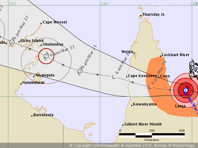

Cyclone Nathan hit the Queensland Coast then blew across to the Gulf of Carpentaria and made a quick beeline for Yirrkala and Nhulunbuy on Sunday morning. We decided to stay at the house and it was OK, a bit windy - a few great gusts - but we were on the edge of the destructive inner circle of the cyclone - the eye passed about 80 kms below us. The major wind died down after about 7 hours and soon everyone was out moving flying branches off the street and we had power back by 6 pm. We were lucky, again. Poor Elcho Island who just got hit by Category 5 Cyclone Lam only 3 weeks ago had to dismantle their emergency tent city and bunker down again. Poor things.


The inner red is the destructive core
The pink circle is the reach of the wind gusts and gales
The blue is the current time and location of the cyclone


Since Ol Nathan has swung past we have had SO MUCH RAIN it is unbelievable ! Torrential downpour. Everything is so so wet and flooded - its quite phenomenal.

Cyclone Nathan is still going - its now just hitting Gunbalanya and Jabiru before turing into a Low just under Darwin. My feeling is it will spit out again past Darwin and reform - then hit the WA coast ... but we will see ...
No comments:
Post a Comment